Climbing Mount Kosciuszko – more of a walk than a hike
Let’s face it: Australia’s highest mountain is a hill — and not even a particularly impressive hill at that. But this doesn’t mean it’s not worth the walk up! The summer wildflowers are stunning, the glacial lakes along the way are beautiful, and it’s fun to take your turn as the highest person on a continent.
Two trails are described here for walking Mount Kosciuszko: a return hike from Thredbo and a loop hike from Charlotte Pass via Blue Lake. The first is the most popular, but the second is by far the most scenic. You can also walk to Blue Lake as a separate day hike.
Distance: 13 km from Thredbo | 22 km from Charlotte Pass
Difficulty: Moderate
Highest point: 2,228 m (Mount Kosciuszko)
Height gain: +400 m/-400 m from Thredbo | +830 m/-830 m from Charlotte Pass
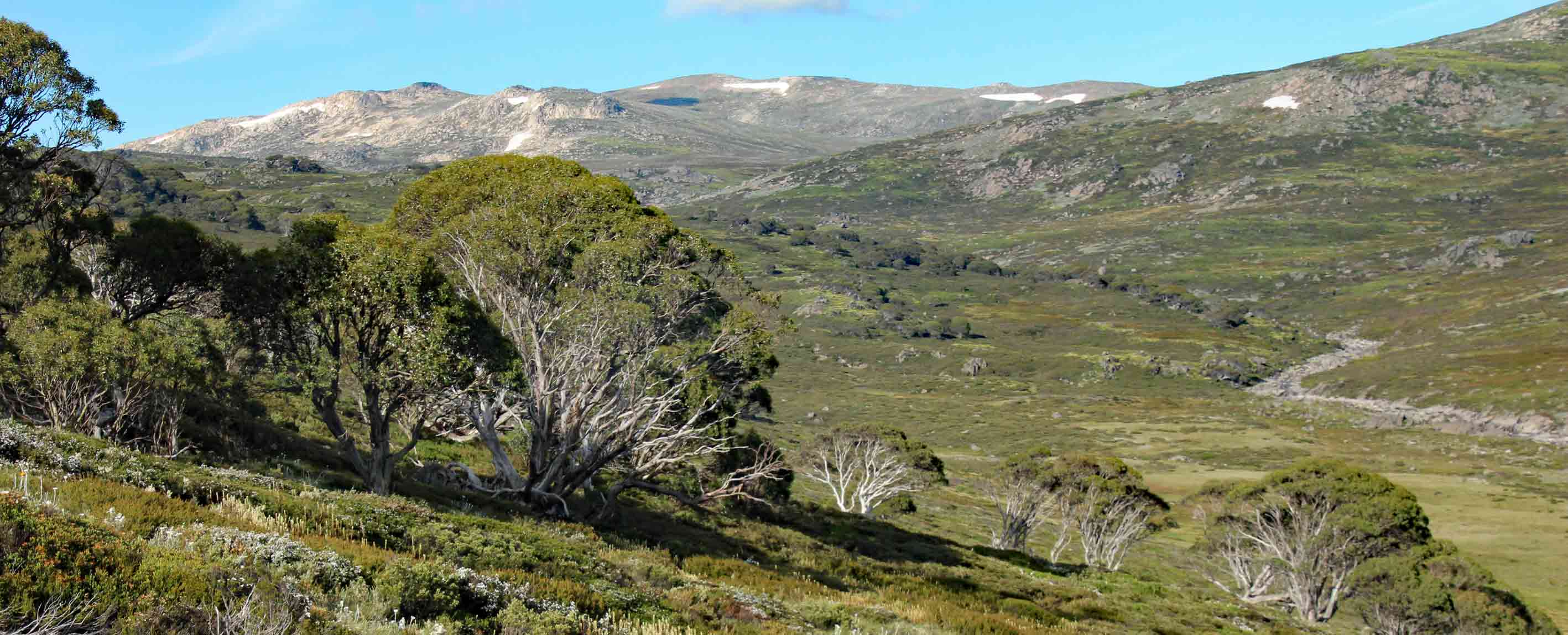
Mount Kosciuszko (pronunciation: Ko-zi-os-koe) is in Kosciuszko National Park in the Snowy Mountains — the highest mountain range on the Australian mainland. The “Snowies” are part of the Australian Alps spanning southern New South Wales and eastern Victoria. They also form part of Great Dividing Range, which stretches down the east coast of Australia all the way from Queensland to Victoria.
A few photos from our Mt Kosciusko walk via Blue Lake


(more photos in the hiking trail descriptions)
5 fun facts about Mt Kosciuszko
- It was first named Mount Townsend — and was thought to be the second-highest mountain in Australia. The real second-highest mountain was thought to the the highest, and called Mt Kosciuszko. When the mistake was realized in 1892, the names of the two mountains were switched.
- It’s named after a Polish-Lithuanian hero, General Tadeusz Kościuszko
- Until 1997, it was spelt “Mt Kosciusko”
- Until 1977, you could drive to the top
- It’s nowhere near the highest mountain on Australian territory. Mount Mawson on remote Heard Island is 2,745 m, and the Australian Antarctic Territory has two that are even higher: Mount McClintock at 3,490 m and Mt Menzies at 3,355 m (though most of the world does not recognize this as part of Australia).
How to get there: Thredbo Kosciuszko walk
The most popular Mt Kosciuszko hike starts and end in the ski resort of Thredbo, on the Alpine Way near Jindabyne, NSW. There’s no public transport to the village. The easiest way to come is by car or private coach (more info here). You need to pay a fee to enter Kosciuszko National Park. Parking is at the Jindabyne end of the resort.
The hike starts at the top of the Kosciuszko Express Chairlift, at the other end of the resort from the car parks.
►Get directions on Google maps
You can also walk directly from Thredbo — see the hiking trail description below for more info.
How to get there: Charlotte Pass to Kosciuszko walk
The longer hike via Blue Lake starts and ends at Charlotte Pass (also incorrectly called Charlotte’s Pass), located at the end of Kosciuszko Road from Jindabyne. There’s no public transport, so the easiest way to come is by car. You need to pay a fee to enter Kosciuszko National Park. Note that the road between Perisher and Charlotte Pass is closed in winter.
The trail starts at the end of the road. Parking is along the side of the main road above the village.
►Get directions on Google maps
Hiking trail description
The trails from Thredbo and from Charlotte Pass are mostly very wide, paved in parts and virtually impossible to miss in summer. Although not so high for alpine terrain, you still need to be prepared for mountain weather (see what to bring below, as well as dangers & annoyances). It was quite windy the day we were there.
There are two shelters — toilets at Rawson’s Pass, which is not far from the summit, and Seamans Hut which is further down the trail to Charlotte Pass after Rawson’s Pass. There are no shops or restaurants along the way.
The vegetation is very fragile so stay on the track. You’re in a national park, so no dogs, fires, or picking flowers.
The track is covered in snow in winter (June-October). You can do either walk with cross-country (nordic) skis or snowshoes, but note that the route is not marked with snow poles.
Thredbo Kosciuszko walk
Follow the Kosciuszko Walk signs from the top of the Kosciuszko Express Chairlift. The track climbs gently the whole way to Rawson’s Pass, where there’s a toilet block — Australia’s highest. Along the way you’ll pass a short side track to Kosciuszko lookout, cross the Snowy River, and pass Lake Cootapatamba, Australia’s highest lake. Turn right at Rawson’s Pass for the final climb to the summit. Return the same way.
Instead of taking the chairlift down, you can walk back to Thredbo via:
- Merrits Nature Track (3.7 km): The trails starts under the top of the chairlift. The pretty walk descends steeply through the bush, ending below the bottom of the chairlift (36°30’12.5″S 148°18’14.9″E)
- Dead Horse Gap & Thredbo River tracks (10 km): Turn off the Kosciusko Walk trail before the chairlift (36°29’31.3″S 148°17’07.9″E). The trail stays high before descending to the Thredbo River. Turn left at 36°31’19.7″S 148°15’49.9″E to return to Thredbo along the scenic Thredbo River Track. The trail ends in Thredbo at 36°30’22.5″S 148°18’03.4″E.
All these trails are well signposted. You could also walk up from Thredbo with these trails.
Photos of Merrits Nature Track


Photos from the Thredbo River Track


Charlottes Pass to Kosciuszko walk via Blue Lake
Three trails start from the end of the road at Charlotte Pass. The short Snow Gums Boardwalk to a lookout is on the right. The old road to Mt Kosciuszko is on the left, now called the Summit Walk. This is the shortest route for climbing Kosciuszko from Charlotte Pass — 18 km return — but also a very boring one. I strongly recommend doing the loop via Blue Lake, Club Lake and Albina Lake … only 4 km longer and much prettier.
We did the hike in an anti-clockwise direction, going first to Blue Lake then climbing Mount Kosciuszko and returning on the Summit Walk. I’m thinking this is better for photos of Blue Lake (due to the position of the sun), but it means a very boring afternoon trudging along the old road back to Charlotte Pass. I’ll describe the walk in this direction — but if I did it again I’d probably go the other way around, to keep the best part for last.
So, take the middle trail, which descends to and crosses the Snowy River. There’s a lovely view of Mt Kosciuszko on the left. After crossing the Snowy River, the trail climbs through alpine meadows and past tarns (small ponds) to a lookout above Blue Lake.


There’s a T-intersection at the Blue Lake lookout. Take the trail to the left, which climbs up to a wide saddle and another T-intersection. You can make a detour up Mount Twynam — Australia’s third-highest mountain — on the right, otherwise take the left path (marked ‘Main Range Track’). The trail climbs again and virtually passes right over Carruthers Peak. This is Australia’s 9th-highest mountain — but we completely failed to realise it was even a mountain. Oops.
The trail flattens out as you pass Club Lake to the left. A bit further along you pass Mt Lee, which I think is Australia’s 15th-highest mountain, but again we failed to realise this. The trail becomes a little rockier as you pass Albina Lake to the right. You pass Mt Northcote to the left (11th-highest mountain which, yes, we again failed to notice) — and rising above Lake Albina you’ll see Australia’s second-highest mountain, Mount Townsend, as well as the 7th-highest, Alice Rawson Peak.


After Lake Albina the trail gently descends for a while before climbing more steeply up to the intersection with the trail from Thredbo. Turn right and join the crowds walking up to the summit.


Take the same path down from the summit, but continue straight ahead to Rawson’s Pass — home to the highest toilet in Australia. The path to the right just before the toilet block is the popular trail from Thredbo; keep to the left to return to Charlotte Pass on the old road. It’s a long 7.6 km slog back… first down to the Snowy River, then on to Charlotte Pass. It gets prettier once you reach the snow gums near Charlotte Pass.


Accommodation & food
Eagle Nest at the top of the Kosciuszko Express chairlift is Australia’s highest restaurant and is open year-round. Thredbo has many restaurants and accommodation options.
The Kosciuszko Chalet Hotel in Charlotte Pass is open in winter and in summer after Christmas, and has a restaurant. You can camp in Kosciuszko National Park, but there are restrictions in some areas. More camping information here.
The closest large town is Jindabyne, which has many restaurants and accommodation options, as well as large supermarkets and other shops. In winter you can stay at Perisher (a ski resort between Jindabyne and Charlotte Pass).
What to bring
You don’t need any special equipment to do the hike in summer. Be aware that this is an alpine area, so you must be prepared for sudden changes in weather, whatever the season.
Essential:
- Good walking shoes
- Water- and windproof clothing
- Warm clothing, according to the season and forecast
- Water
- Food
- Sunscreen
- Hat
- Snowshoes/cross country skis (winter)
- Hiking poles
- Insect repellent
- Map, compass, GPS (essential in winter)
Dangers & annoyances
- Death by snake or spider bite: KIDDING! Everyone thinks Australia is crawling with deadly creatures, but it’s very unlikely you’ll encounter anything dangerous. And even if you do, as long as you keep your distance won’t be bitten. The rest of the risks in this list are real, however.
- Fires: Australia is prone to bushfires in summer — check the Fire Danger Rating at the Snowy Region Visitor Centre in Jindabyne before starting: +61 2 6450 5600
- Sunburn: The sun is dangerous everywhere in Australia! Apply plenty of sunscreen every two hours — and even better, cover up as much skin as possible.
- Heat stroke/dehydration: Australia is also prone to heat waves in summer, and you’re out in the sun the whole time on this hike. Wear a hat and make sure you bring enough water for the weather conditions. You can check the weather here.
- Hypothermia/exposure: The weather could also quickly turn cold — and windy. There may even be snow in summer. We did the hike during an exceptionally hot spell in January, and we all wore fleeces and rain jackets due to the wind.
- Flood: It’s not recommended to cross the Snowy River if the stepping stones are not visible.
- Stomach bugs: It’s also not recommended to drink river, stream or lake water due to E.coli and other nasty bugs.
- Snow: As mentioned above, it can snow at any time of year — and under deep snow, you won’t be able to see the trail. Only very experienced cross-country (nordic) skiers or snow-shoers with good map-reading skills should attempt the trail in winder.
- Flies: Honestly, the flies weren’t as bad as I had feared. I still recommend taking insect repellent though.
Hiking trail map – Thredbo to Kosciuszko walk
GPX download under the map. The map does include the Merrits Nature Track, Dead Horse Gap or Thredbo River Track options — but these are well-signposted. Zoom in on the map below to see them.
Hiking trail map – Charlottes Pass to Kosciuszko walk via Blue Lake
GPX download under the map.
3 comments
I’m planning to hike Mt Kosciuszko in January. For how long (how many hours) would you estimate a hike from Thredbo and back (without using the chairlift)? I know that this number is different for different people, but what would be an estimation for a moderately fit adult?
I’d guess about 8-9 hours, if you took Merrits Nature Track to the top of the chairlift and back (nearly 4km each way). Enjoy your hike, it’s really beautiful in January. It would be great if you could report back on how long it actually took you!
[…] Both Kosciuszko trails are mostly very wide, paved in parts and virtually impossible to miss in summer. The tracks up from Thredbo are also good and well signposted. You’re in alpine country so you do need to be prepared for bad weather, and you’ll need to take enough food and water. But otherwise there’s no excuse not to make your pilgrimage up Mt Kosciuszko! – Emma Duncan – World Best Hikes […]