★★☆☆☆ | Easy to moderate options | Trail & rock climbing possibilities
The bisse du Ro is in the Swiss Alps, near Sion and the ski resort of Crans-Montana in the canton of Valais.
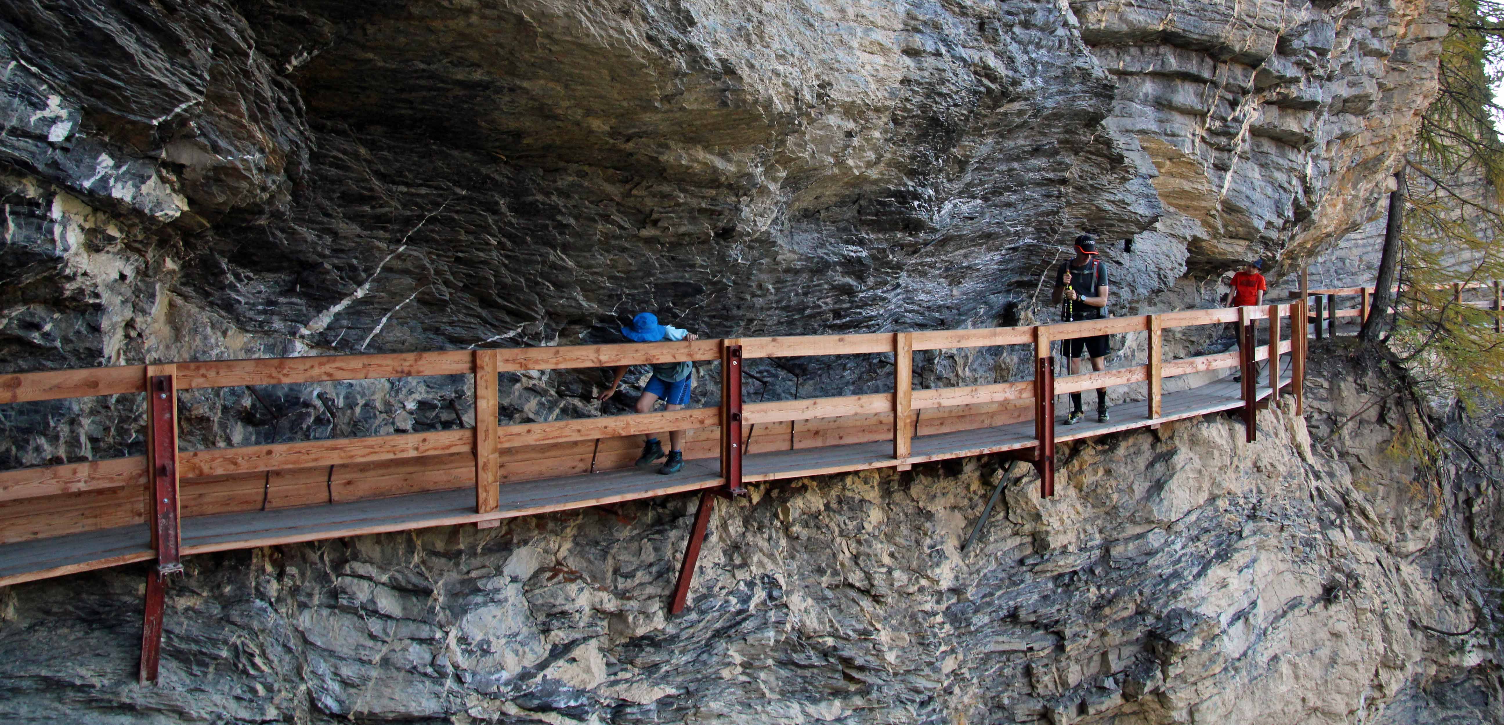
The path follows along an old irrigation channel — a bisse — created to bring water from the mountains to the vineyards and orchards lower down. Most bisses are dug out of the earth or rock, but the bisse du Ro runs along cliffs in a few places. This meant attaching planks to the cliff face and then placing wooden canals on top of the planks — which, considering the bisse was built in the 12th century, was a massive feat!
The walk offers great views of the mountains across the valley to Anzère. We combined the bisse walk with a side trip into these mountains, to Lac de Tseuzier.
Hiking trail info – Bisse du Ro & Tseuzier lake
There are a number of starting and ending options. We started in the car park in west Crans (46°18’20.3″N 7°27’33.6″E), but then saw you can park closer to the trail head, on Rue du Pont de Diable (at around 46°18’27.3″N 7°27’14.9″E). You could also start at the lake and walk down to Crans — or even start and/or end lower down.
The walk along the bisse is mostly a stroll through the forest along a mountainside, with plank bridges to traverse the cliff faces. There are some scary pictures online of rickety planks resting on not much, but don’t be put off: this was when the path was under construction. As you can see from our pictures, the bridges are very secure now. There is one exposed section, but it’s not too bad.
The trails after the bisse are regular hiking trails, and well marked.
Crans is served by public transport, as is Lac de Tseuzier. There are many eating and sleeping options in the area. There are no restaurants or shelters along the trail, but Google tells me there is a restaurant at Lac de Tseuzier.
Easiest hike: Crans – Bisse du Ro – Crans
Highest point: 1,662 m
Height gain: approx 325 m
Technical details: mostly a very good path or board walk; short exposed section with danger of rockfall
Distance: 9.4 km
From the trail head on Rue du Pont de Diable, follow the walking signs for Lac de Tseuzier. There’s a short climb up to the bisse then the path is more or less flat along the bisse, which follows the mountainside. You have to duck in a few places as you traverse the cliffs. There are panels along the way explaining the history of the bisse, as well as a few benches and a picnic table.
You’ve reached the end of the bisse by the time you get to the exposed part — 200 m where it’s forbidden to stop due to the danger of rockfalls. It sounds scarier than it is. The path continues along the mountainside to the head of the valley, where there are more picnic tables. Take the same path back to Crans.


Harder hike: Crans – Bisse du Ro – under the cliffs – Crans
Highest point: 1,662 m
Height gain: approx 615 m
Technical details: steepish trail in parts; short exposed section with danger of rockfall
Distance: 10.2 km
From the end of the bisse du Ro, follow the signs to Lac de Tseuzier until the turn off for the grande bisse de Lens on the left — take this turn off.
The path takes you down through the forest and under the cliffs you traversed while following the bisse du Ro. At some point there’s a fork for Crans or the grande bisse de Lens — follow the left path to Crans. Walking down means, of course, walking back up — this part is a little steep. You end up where you started at the path for the bisse du Ro.
Alternatively, you could keep following the grande bisse de Lens trail. This route is marked with a big sign saying it’s not recommended for people suffering from vertigo. We were immediately tempted to take it, but didn’t have enough time (as the trail ends up lower than Crans, where our car was parked). We’ll definitely be back to do it another day!

Moderate hike: include a side trip to Lac de Tseuzier
Highest point: 1,820 m (just above Lac de Tseuzier)
Height gain: approx 800 m
Technical details: steepish trail in parts; short exposed section with danger of rockfall
Distance: 18.4 km
From the end of the bisse du Ro, keep following the signs to Lac de Tseuzier. The path is a little steep in places. Once you’ve finished admiring the lake, walk back the same way until the turn off for the grande bisse de Lens on the right– take this turn off to return to Crans under the cliffs, as described above.


Map for our hike: Crans – Bisse du Ro – Tseuzier lake – under the cliffs – Crans
(GPX download under the map)