Hiking in Zermatt, Switzerland – excellent trails & fabulous views
The Matterhorn is Switzerland’s most iconic mountain. And for picture-perfect views of this world-famous peak, you can’t do better than the 5 lakes hike, Zermatt. Also called the 5-seenweg, this beautiful trail is an enjoyable walk for adults and children alike. Access is easy and no special hiking skills or equipment are needed in summer.
Distance: ∼9 km
Difficulty: Moderate
Highest point: 2,571 m (Blauherd)
Height gain: +232 m/-503 m
| GO STRAIGHT TO: |
|---|
| ► Photos ► How to get there ► Hiking trail description ► Where to stay and eat ► What to bring ► Dangers & annoyances ► Hiking trail map  |
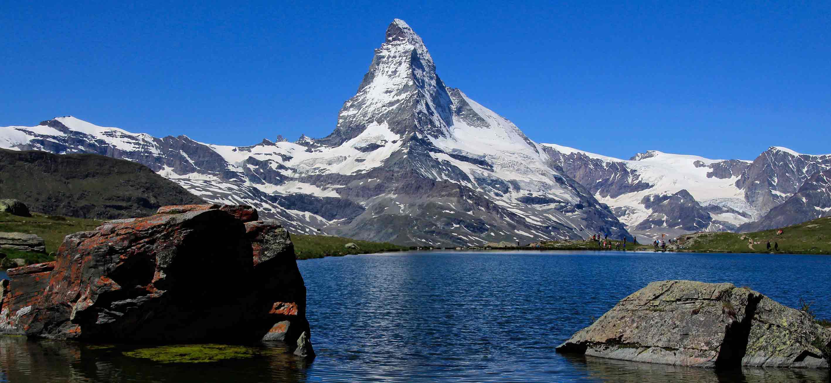
The Matterhorn is in view almost the entire hike and, on a still day, reflected in three of the lakes: Stellisee, Grindjisee and Leisee. Add in alpine pastures, marmots, a few cows and generally stunning scenery — and you’ve got the very best of hiking in Switzerland.
The five lakes are located high in the Swiss Alps above the village of Zermatt — but don’t worry, you don’t have to walk all the way up. The trail conveniently starts at the top of a gondola and ends at the bottom. It’s not all downhill, but neither is it very hard. We did it with children aged 7 to 10, who don’t usually walk that much, and it was no problem. If you are in Zermatt, then you should definitely do the five lakes trail!
Photos from our 5 lakes hike, Zermatt


How to get to Zermatt
Zermatt is located at the end of the Matter valley in the canton of Valais, Switzerland. The famous Matterhorn sits at the head of the valley, on the border with Italy.
Apart from electric taxis and buses, Zermatt is car-free. To get there, you need to take a shuttle train from the village just before, called Täsch (46°04’04.1″N 7°46’32.6″E). This runs every 20 minutes and takes 12 minutes — see the schedule here. You can either take the regular train to Täsch or drive. There is a huge car park at Täsch station, so parking is no problem.
The 5 lakes trail (5 Seenweg in German) starts at Blauherd ski station. To get there, first take the underground funicular railway from Sunnegga valley station in Zermatt (Express Bayard Zermatt: Vispastrasse 32, 46°01’21.2″N 7°45’06.5″E) to Sunnegga, then take the gondola chair lift to Blauherd. The trail finishes at Sunnegga, where you can take the funicular back to Zermatt.
►Get directions on Google maps
5 lakes trail description
The trail is good and well-marked. It’s reasonably high though, so be prepared for mountain weather (see what to bring below). Apart from a few restaurants along the trail and the various ski lift stations, there is no shelter along the trail. You can swim in Leisee and Grünsee.
The trail starts behind the Blue Lounge building directly in front of the gondola terminus at Blauherd, descending to Stellisee and then to the top of the Findeln glacier moraine. It flattens out along the top of the moraine, running through a grove of trees and just under Grindjisee — don’t miss this lake like we did!
After Gringjisee the trail goes down the enormous and spectacular moraine to the Findeln river. After this it’s a flat walk down the valley to Grünsee, followed by a descent through forest to the 4th lake, Moosjisee. The trail next runs through marmot-filled pastures, climbing first to a small hamlet, then to the last lake, Leisee, and finally finishing at the Sunnegga station.
Note that the last trip back down to Zermatt from Sunnegga is at 17.30.
Where to stay & eat
On the trail, there’s a cafeteria-type restaurant at Sunnegga, a restaurant just past Grünsee and other restaurants in the hamlet below Leisee. Note that the restaurants are not open all year long: only the cafeteria at the end of the hike in Sunnegga was open when we were there in late June.
You’ll find many restaurants in Zermatt, as well as supermarkets. The youth hostel has the cheapest accommodation, otherwise there are many hotels. There are also many restaurants and hotels in Täsch.
What to bring
You don’t need any special equipment to do the 5 lakes walk in summer. Be aware that it is in alpine terrain, so you must be prepared for sudden changes in weather. There could also be snow on the trail well into Spring.
Essential:
- Good walking shoes (hiking shoes recommended but not essential in summer)
- Water- and windproof clothing
- Warm clothing, according to the season and forecast
- Water
- Snacks
- Sunscreen
- Hat
- Map
- First aid kit
- Hiking poles
- Bathing costume
- Picnic lunch
Dangers & annoyances
-
- Sunburn: Apply plenty of sunscreen every two hours — and even better, cover up as much skin as possible. Note that you can still get burnt on an overcast day!
- Heat stroke/dehydration: If the weather is clear then you’ll be in the sun for most of the hike. Wear a hat and make sure you bring enough water for the weather conditions. There is water along the trail but…
- Stomach bugs & parasites: It’s not recommended to drink river, stream or lake water due nasty microorganisms.
- Hypothermia/exposure:
The weather could quickly turn cold and windy. Take warmer clothes, even if it’s sunny when you start out.
Hiking trail map
(gpx download under the map)